Translate

Thursday, August 30, 2012

Return to civilization

The track back
Thursday's track back to civilization and the conclusion of a great trip.
Almost round

Some thirty minutes after leaving St. Bernard's Cove, Dean and I arrived at the northern tip of Merasheen Island.

Grabbing hold

Dean grabs a hold of Merasheen and our circumnavigation is complete.  It was hard to believe six days had passed since we were last in the same spot.

The others arrive

The rest of the crew arrives.  We linger for some time to enjoy the moment, the feeling of accomplishment before we cross the central channel to Long Island and then on to Arnolds Cove.

Oily calm seas

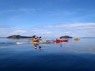
On a bright, clear and calm day we crossed in front of Bread and Cheese Islands on our way to Arnolds Cove.

A long way off

Arnolds Cove still lay a long way off in the distance but we could see where we were headed.  Last year on the same crossing, we did it in fog having to rely on the compass.

Land ho!

At the entrance to Arnolds Cove I stopped to take a picture of Dean.  We had a look back to where we had come from before paddling the last few strokes onto the beach.

Arrival

Clyde, Dean and I were on the beach as Hazen and Neville paddle in.  Behind them, on the far distant horizon, barely seen lay Long and Merasheen Islands.

It was an epic trip, at least it was for us.  It seems like every trip I do is an epic trip until I do the next one.  This one was special though.  Not a lot of people paddle to Merasheen so it is very much the road less traveled.

 Fish and chips
With all the gear packed into the vehicles we drove the short distance to Megan's Restaurant where we had a great meal of fish and chips.  I had a three piece.  I felt I deserved it.
Here's a picture of the happy gang.  Clockwise from left: Dean, myself, Clyde, Neville and Hazen.  Thanks guys for an excellent trip, one I will always look back on withfond memories.

Wednesday, August 29, 2012

The road home

Breakfast

We woke on Thursday, the sixth day of our trip around Merasheen Island, to news the weather would be against us for the next two days after the day.  We decided we'd pass on further exploration of the Ragged Islands and paddle direct to Arnolds Cove and the conclusion of our trip.

But first we had breakfast, punctuated with blueberries Neville picked.

Into Bests Harbour

We hauled the empty boats the short distance over the neck and into Bests Harbour, deciding to take the inner reach between King and Merasheen Islands.

Thanks Ern

Ern came down to our campsite in his boat to give us the forecast.  We had a brief chat, thanked him and paddled down Bests Harbour and into the reach.

Riley Island

A low tide at Riley Island meant we had to knuckle walk the kayaks over the barely submerged bar.

Protected passage

We proceeded on up the reach in calm waters.

Big Dog Harbour

Neville paddles across the entrance to Big Dog Harbour as a gentle breeze blew out of the southeast.

Mussel farm

Nearing Hound Island we reached the mussel farm Ern had told us about.  The floats of the farm stretched as far as the eye could see at water level.  It was an impressive sight.  Each float supported a strand of rope on which the mussels grew.  On another day we might have harvested a few for a meal.

Out of the reach

We exited the reach between King and Merasheen Islands and into more open waters, still populated by small islands.

St. Bernard's Cove

St. Bernard's Cove is on the other side of a narrow neck from Great Brule and a good place to stop for lunch.

Familiar place

It had a familiar look to it because only six days previous we had stopped on the right hand side of the scene for lunch on our way south on the east side of the island.  We had seen much and done much in the intervening days.

Two crossings and our adventure was coming to an end.

Tuesday, August 28, 2012

Ashes to ashes

Piled up

On the fifth night of our trip we again had a fire on the beach.  It is as much a part of our kayak trip as the paddling itself.  Before it got too dark we gathered wood for the fire and piled it near where we intended to have the fire.

Kindling

At the appointed time the smaller wood is put into a small pile and we light the fire.  Its just getting underway.  Also at this time we pour our first drink.

Adding wood

Once the smaller stuff gets going we start adding the bigger stuff.

More like it

After adding the bigger sticks the fire takes on a life of its own.

Its at this point where the fire becomes entertaining.  We all peer into the fire as if it was a habit engrained in our DNA.  And, surely it must be after countless generations of our ancestors huddled around fires for warmth and safety from the wild animals and spirits lurking in the shadows.

Surprise

When the fire burns down near the end of the night and its safe, Neville surprises us with some Jiffy Popcorn.

Starburst

As it gets late and the fire is on its last legs we scatter the ashes for safety sake.

The ashes pulse and glow.  I take a picture that reminds me a bit of something Hubble might take a picture of - millions of stars.  So, in a way our fire has come full circle.

It would be our last fire for the trip.

Monday, August 27, 2012

On walkabout at Tacks Beach

Old Tacks Beach

Ern Penny was the lone occupant of Bests Harbour when we arrived from Merry Harbour on the fifth day of our Merasheen adventure.  We walked over to see him in Bests Harbour for a chat.  After some time he invited us into his home where I took this shot of a framed picture of Tacks Beach (foreground) and Bests Harbour (afterground).  It was useful as it put our walkabout in Tacks Beach in perspective.

Notice the "roads" leading around the harbour and to the church.

Hi there!

Someone who still visits Tacks Beach had a sense of humour.  I would probably have been more appropriate to have it facing out over the entrance to Tacks Beach.  I asked Ern about the name.  Was there a family of Tacks I asked?  No, apparently it was named such because schooners would tack into the harbour.

Traditional stage

A disappearing sight in Newfoundland, the stage served as a place to split and salt cod fish, store fishing equipment and a place to take the drying fish into when it rained.

Hanging on

An old wharf stretches into Tacks Beach harbour where a few of the relocated residents have summer places and hang on to memories of grander times.  Grander times indeed.  Tacks Beach was settled in the early 1800s.  The population reached a peak of 251 persons living in 49 households.

Foundations

 Perhaps one of the 49 families lived here where all that's left are the concrete foundations of what looked to have been a house.  The rounded edge of each pillar show where the sills for the house were laid before the concrete set.

Dearly departed

Tacks Beach was abandoned in 1966.  They left behind the ancestors but obviously not forgotten.  Someone is keeping the graveyard neat and tidy and propping up the fallen headstones.

Here lies Henry Brown

I didn't find it difficult to imagine being here a few days after Henry Brown departed this life on August 28, 1899.  I wondered about how many people stood around the grave to grieve as he was lowered into the earth.  At 78, he would have lived a full life, probably had a large family and formed many friendships.

Clyde, Dean and I walked around the cemetery.  I sensed a feeling of reverence.

The church

This is all that remains of the church after almost 50 years since the community was abandoned.  The church usually occupied a predominant place in outport Newfoundland; its position can be clearly seen in the first picture, the one I took at Ern's.  Where houses may have been towed away or disassembled, the church was left to return to the earth.

It was an interesting walkabout at Tacks Beach.  I think we were left with  sense of what the community was like when the last person turned out the lights.

With, that, we walked back to our campsite on the neck to prepare for our usual fire on the bech.

Sunday, August 26, 2012

Moving on to Tacks Beach

The track to Tacks Beach

We made our way to Tacks Beach by the outside of King Island.  The batteries ran out on my GPS so I added the final part of the track freehand in red.

Leaving Merry Harbour

On the fifth day we left Merry Harbour where we had spent two nights.  I can safely state that the place is aptly named.  We crossed the expanse of sea from Merasheen to the Lower Gray Gull Islands.

 Something interesting

As Dean and I reached the Lower Gray Gulls Islands I noticed this mafic dyke intruded into the pink granite rocks.  I'll say mafic because I don't know the composition, just to connote its dark appearance.  It may be a rhyolite and related to the granite?

Entering Smiths Cove

Entering Smiths Cove with Green Island to port, King Island to starboard.

 No name islands

There are so many islands in the Ragged Islands, reputed to be 365, that not all have names.  Some are just hummocks stuck out of the water.  We're almost through them here as the Burin Peninsula of the mainland hovers on the horizon.


A quick stop

We made a quick stop in Doting hole, a deep inlet into King Island.

 Caribou

At the entrance to The Grandies we stopped to eat lunch.  As we entered I spotted a caribou and paddled quietly as close as I could to take a picture before spooking it.  It stopped long enough to pose for the camera before taking off into the trees.

Exiting The Grandies

Its called "The Grandies" on the map but I didn't find anything particularly grand abut the place, not anymore than the fine scenery we had been paddling in all day.  Out of The Grandies we paddled through Broad Cove and into Tacks Beach.

Tent city

The north end of the neck was the most protected spot to put the tents.  As we did Ern Penny, the lone occupant at Bests Harbour came over to chat with us.  Bests Harbour is on one side of the neck, whereas Tacks Beach is on the other.  I probably could have all been called by one name.  In any case, our arrival at Tacks Beach increased the population in the area five fold, Ern being the lone occupant before our arrival.

Bests Harbour

Looking east towards Bests Harbour.  Here King Island is almost cut in half except for the 50 meter wide neck where we were camped.

Water haul

A previous trip report on Kayak Newfoundland and Labrador's website indicated there was a well at Tacks Beach.  Ern confirmed that and gave me directions.  Clyde and I followed the path northeast to the first cabin; the well was located just behind it.  Instead of tannin coloured water to filter we had crystal clear water.  Crystal clear but it was filtered anyway.

We cooked supper.  I had salmon cakes, a nice change from the rice and pasta so far.  We may have been roughing it but there was no reason not to eat well.

Saturday, August 25, 2012

A day in the Ragged Islands

Chicken tracks in the Ragged Islands

On day four of our trip around Merasheen Island we took a day detour to paddle around some of the Ragged Islands.  Apparently, at low tide, there are 365 islands in the group, one for every day of the year.  However, we only did a sample.

Doug Redmond and Dan Murphy in their book "A Guide to Sea Kayaking in Newfoundland and Labrador" state "Lifestyle guru Martha Stewart has kayaked among the Ragged Islands.  After paddling the Ragged Islands she commented, "it was one of the best kayak trips [she had] done!"

Who am I to disagree with Martha Stewart?

 Leaving Merry Harbour

We left our tents standing at Merry Harbour and paddled our now much lighter kayaks across to the Ragged Islands making the Jarvis Islands our first target.

Islands in the stream

From the water it looked like it could all be one land mass but as in a painting, the darker forms indicated they were closer and separate islands.

Obstacle

Jarvis Islands had a channel between on the map so they looked a interesting first look.  At low tide they happened to be joined.

A drag across

We could have turned around but decided to pull the kayaks over the seaweed covered rocks.

Pink granites

The pink granites in some of the islands added some nice colour.

Moor Island

We turned east to check out more islands, this one is Moor Island, with Jean de Gaunt Island partly shrouded in fog behind it.

Exiting

We almost exited the archipelago at Jean de Gaunt Island to starboard, Big Dock and George Dock Islands on port side to see the Burin Peninsula on the horizon.

Lunch stop

After circling around Crane Island we paddled into Jean de Gaunt Harbour where we stopped for lunch.  The day that started overcast with a bit of fog got sunny and hot.

Shedding

Sometimes we are creatures of habit - put on drysuit, go paddling.  I don't remember who said they were taking off their drysuit first but we all did.  There was really no need to wear our drysuits because the water was almost bathtub warm.  I certainly felt a greater freedom with the drysuit in the hatch.

Harbour Islands

Hazen paddling along in the indistinguishable Harbour Islands.  Up close the various islands all looked the same, some too small to appear on the map.

Squeezing through

After paddling past South Tilt Island we started to make our way back towards our camp at Merry Harbour.  Here we are squeezing between two of the Lower Gray Gull Islands.

Fire on the beach

We had our usual fire on the beach with refreshments after supper.  At one point a section of sky cleared to reveal the constellation Cassiopeia.  The recognizable open W shape that city dwellers can only see due to light pollution was populated by a myriad of other stars only visible in the total darkness of the wilderness.