Translate

Showing posts with label Crants Cove. Show all posts

Monday, July 28, 2014

The graveyard at Crants Cove


When you paddle around the point from Stones Cove the first thing that catches your eye is the massive hill and then the white grave headstones beneath it.  We got out at Crants Cove to have a look.


The community of Crants Cove is another of the hundreds of resettled communities of Newfoundland.  When the residents left, they left behind the history of the community as embodied in the white tombstones.


The graveyard is all overgrown with only the markers along the edges visible.  Somewhere in there many more are hidden.


A gagged line of headstones look out upon a sea where the livelihood of Crants Cove swam.


We had gotten out for a walk around Stones Cove before arriving at Crants Cove.  It was a barren, rocky place and we remarked that vegetable farming must have been impossible there are there was very little topsoil.  I walked farther inland to see if there was a graveyard because I was told there was one.  There wasn't.

The mystery was solved though at Crants Cove.  I snapped some shots of the headstones to research them later at home.  This one marks the final resting place of Martha Thornhill.  A search of the 1921 census showed she was a resident of nearby Andersons Cove.
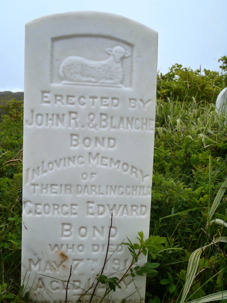

The Bond name is prominent in the census of Stones Cove.  A review of the 1921 census showed the parents of George Edward Bond, John R. and Blanche, resided in Stones Cove.  Their child George died in 1916 at one day old but the census indicated they had two other children in 1921.  It was  harsh place and if there were complications at birth there wasn't anything anyone could do to change fate.


Two more children of Thomas and Ida Francis of Stones Cove lie here.  Emily Ellen at eight days and John Robert at 6 1/2 months.  It had to be heartbreaking for the parents, the little lamb left for us to ponder how fragile life was without modern medical attention.


So, the mystery of the graveyard for Stones Cove was solved.  They and the residents of nearby Andersons Cove buried their loved ones in Crants Cove, the only place with enough soil in which to dig a grave.

As I walked around the outer edge of the graveyard I wondered what kind of life these people had.  There were dangers living in such isolated places but there must also have been great rewards.

The struggle for survival would have been tenuous with food coming from the sea and land.  Meat would have consisted of rabbits and caribou and vegetables probably consisting of mainly potatoes grown in the precious little soil.  Wild berries supplemented the diet.

They would have had a close knit community where everyone pulled together and while they had worries, they didn't have some of the worries we have today.  I suspect in many ways they were more carefree.

Those people are gone and their descendents scattered who knows where.  I wonder if any give a thought to the those left behind on that barren outcrop of land very few people visit anymore?

Wednesday, July 29, 2009

Crant's Cove

First view of Crant's Cove

This was my first view of Crant's Cove from the seat of my kayak as I rounded the point coming from Anderson's Cove. There are no visible signs on the land that there were ever buildings here but the number of headstones made it look like this was a bustling community at one time. Not so.

Crant's Cove was settled by the families Crant and Stone. The Stones subsequently moved one cove over to the left and grew to be larger than Crant's Cove. The 1921 census of Newfoundland doesn't have a listing for Crant's Cove so it must have been inhabited by a very small number of people, maybe just the Crants themselves.

I had a quick look at the names on the headstones. They included Pope, Thornhill and Bond; all names that appear on the census for Anderson and Stone's Coves. I suspect that these communities used the land at Crant's Cove to bury their dead due to shortage of suitable land in their own communities.

If I get back here in the future I'll take more time to check more headstones.

Crant's Cove

Looking over the cove and the cemetary on the point. The cove is not very deep and doesn't offer much protection from the prevailing winds. This view is northeast.

Premium land in a rocky landscape

We had been to Anderson's Cove where it didn't look like there was much arable or flat land for raising of vegetables, yet in its day Anderson's Cove had a bigger population than Crant's Cove. After leaving this place we went to Stone's Cove where the terrain didn't look as good either. That made me wonder if protection from the sea was more important than usable land to people who settled in the area. Probably was.

Family Dominix

The name on the headstone was "Dominix"; sentinals looking southeast over the entrance to Crant's Cove. There are no names Dominix on the 1921 census for the communities in the area so they must have migrated to the area in more recent times.

Sunday, July 26, 2009

Places lost

Loaded up and ready to go

Stan proposed an overnight kayak camping trip earlier in the week. Some discussion and we settled on a paddle from Harbour Mille in Fortune Bay to the resettled community of Stone's Cove. Stan just wanted to paddle somewhere new, I thought visiting some of Newfoundland's historic abandoned communities would be a great added feature.

Scott Walden had visited the Province of Newfoundland some years ago with the intention of photographing the remains of some of Newfoundland's resettled communities. The result of that visit was a book entitled "Places Lost". These were isolated settlements that the Government of the day thought should be moved and the inhabitants consolidated in larger communities for access to modern conveninces.

We got into Harbour Mille Friday afternoon hoping to cross so that we'd have more paddling time on Saturday. It didn't happen as it was blowing with many whitecaps visible. We toured Harbour Mille and after some (too long for words) scouting, we found a nice spot off the road to put up our tents and catch some Zs for an early morning rise.

We got out of our sleeping bags around 4:30 am, made breakfast and headed to the harbour to put-in.

Stan making progress in choppy waters

We had to make a 5 km crossing of the northern part of Fortune Bay to get on the far shore that would take us to our destination of Stone's Cove.

It was better but still choppy. Not a problem for our fully loaded Nordkapps. I couldn't believe the handling of the boat with a bit of weight in it.

Stan paddles along some massive red cliffs

This stretch of shore is exposed to south and south-western winds but today after we crossed the northern reaches of Fortune Bay the wind dropped and the water went calm. We were very fortunate and relieved to find that the wind had dropped so we could take our time to enjoy the scenery on offer today.

Lunch beach at Friar Head

We got the boats ashore an cooked lunch. Stan and I both made lunch and then halved it to give each other a different taste, so we had a smorgasbord!

Done lunch and cleaning up afterwards, Stan wanted to hike up to the hill overlooking the beach to see what was visable over the surrounding country. There wasn't much to see but turning back we has this great view looking back the bay and the great beach where we landed.

Here lies Sabine Hatch

Our first destination after lunch was Anderson's Cove. Stan spoke to a colleague at work who informed him a bit about Anderson's Cove so we wanted to visit there. We turned north into Long Harbour and Stan noticed the solitary grave overlooking Lobster Cove just inside the entrance to the "fjord" called Long Harbour. I had to get out to have a look and Stan patiently waited.

The name on the headstone was Sabine Hatch and she passed away in 1890 at the age of 36 years. Death at an early age was common for people living in the isolated bays of Newfoundland which locally are called "outports".

Crant's Cove

We left Long Harbour and paddled to Crant's Cove around Long Harbour Point. Crant's Cove is one of the resettled communities features in Scott Walden's book "Places Lost". We came into the cove, with me thinking it was Stone's Cove. I recognized the graveyard with the massive hill behind it and thought it must be Crant's Cove, a community started by the Crants and Stones. The Stones subsequently moved over a cove to the left and settled Stone's Cove which went on to overshadow Crant's Cove in terms of size. Odd I thought as there were many more gravestones at Crant's Cove than at Stone's Cove.

I landed to get check out the graveyard and noted the family names of Dominix, Thornhill, Scott, Bond and notably Pope. That was interesting as we spoke to a fisherman earlier in the day who said his Grandmother was from Crant's Cove and her name was Pope.

Not only is Crant's Cove a place lost but so are the names of most of these families in the immediate area.

Stone's Cove

Next stop after Crant's Cove was Stone's Cove which is also featured in "Places Lost". Stone's Cove is another one of Newfoundland's resettled communities. There was a substantial church and numerous houses but more on that later. It might have been abandoned but sometime later a few came back and built cabins to use when fishing in the area, repleat with satellite dishes!

Home sweet home

When we left Stone's Cove the wind picked up as did the seas. We had some challenging seas but I was impressed again how well the fully loaded Nordkapp handled in the quartering seas. Where to spend the night? I left it up to Stan and he led us back to Lobster Cove just inside the entrance to Long Harbour. Stan chose well as inside here it was calm.

We unloaded the boats, put up the tents and cooked supper. Cooked supper if you can call boiling water to dump into dehydrated food cooking! We chose for simple on this trip.

Spellbound

After we made supper and washed the dishes (!!!) Stan and I picked up some firewood on the beach and had a fire. Something about a fire, ever changing, ever consuming, that is spellbinding. This was our entertainment for the night. It looked a bit like two guys looking at the idiot box but unlike TV, there was time to yak it up in between gathering wood to keep the "home fire burning".

At about 9:30 it started to rain and blow so we retreated to the comfort of out tents and sleeping bags. I wondered what tomorrow would bring for our trip home. We didn't have the luxury of a weather day.

Safe and out of the weather as the rain pounded the tent, I reflected on a fantastic day paddling with good friend and paddle mate Stan. 30 kms paddled wasn't a bad effort.