2 days ago
Showing posts with label Stones Cove. Show all posts
Monday, July 28, 2014
The graveyard at Crants Cove
When you paddle around the point from Stones Cove the first thing that catches your eye is the massive hill and then the white grave headstones beneath it. We got out at Crants Cove to have a look.
The community of Crants Cove is another of the hundreds of resettled communities of Newfoundland. When the residents left, they left behind the history of the community as embodied in the white tombstones.
The graveyard is all overgrown with only the markers along the edges visible. Somewhere in there many more are hidden.
A gagged line of headstones look out upon a sea where the livelihood of Crants Cove swam.
We had gotten out for a walk around Stones Cove before arriving at Crants Cove. It was a barren, rocky place and we remarked that vegetable farming must have been impossible there are there was very little topsoil. I walked farther inland to see if there was a graveyard because I was told there was one. There wasn't.
The mystery was solved though at Crants Cove. I snapped some shots of the headstones to research them later at home. This one marks the final resting place of Martha Thornhill. A search of the 1921 census showed she was a resident of nearby Andersons Cove.
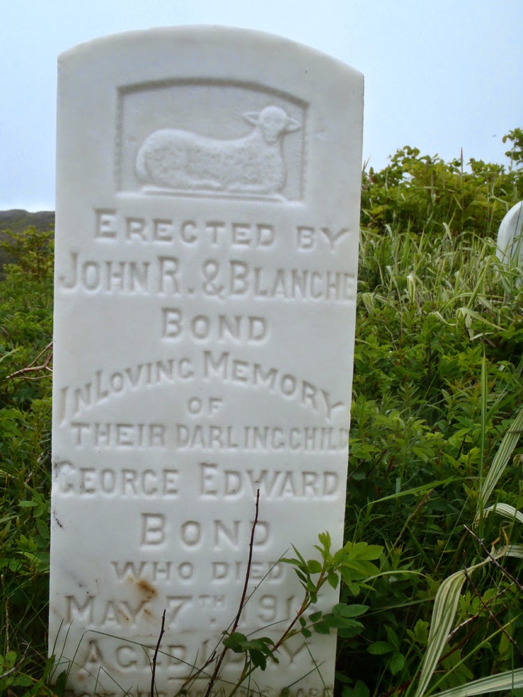
The Bond name is prominent in the census of Stones Cove. A review of the 1921 census showed the parents of George Edward Bond, John R. and Blanche, resided in Stones Cove. Their child George died in 1916 at one day old but the census indicated they had two other children in 1921. It was harsh place and if there were complications at birth there wasn't anything anyone could do to change fate.
Two more children of Thomas and Ida Francis of Stones Cove lie here. Emily Ellen at eight days and John Robert at 6 1/2 months. It had to be heartbreaking for the parents, the little lamb left for us to ponder how fragile life was without modern medical attention.
So, the mystery of the graveyard for Stones Cove was solved. They and the residents of nearby Andersons Cove buried their loved ones in Crants Cove, the only place with enough soil in which to dig a grave.
As I walked around the outer edge of the graveyard I wondered what kind of life these people had. There were dangers living in such isolated places but there must also have been great rewards.
The struggle for survival would have been tenuous with food coming from the sea and land. Meat would have consisted of rabbits and caribou and vegetables probably consisting of mainly potatoes grown in the precious little soil. Wild berries supplemented the diet.
They would have had a close knit community where everyone pulled together and while they had worries, they didn't have some of the worries we have today. I suspect in many ways they were more carefree.
Those people are gone and their descendents scattered who knows where. I wonder if any give a thought to the those left behind on that barren outcrop of land very few people visit anymore?
Sunday, July 27, 2014
Looking for the Stones of Stones Cove
On our way to Lobster Cove in Long Harbour we stopped at the location of the resettled community of Stones Cove. First we cooked lunch and then Dean, Hazen, Neville and I had a look around. All that's left of the community are concrete foundations and a some rotting lumber.
Here, a set of steps must have led into a house.
Concrete monoliths stand alone now in the grass where once a community of almost 200 persons lived. The census for 1921 listed 191 persons living in 36 households.
Here lie the remains of the community church.
Another remnant of pillars and notches to accept the wood for the structure above it.
Some of the more numerous names found on the census include Elms, Bond, Pope and Hatch. But, oddly enough, no people with the name Stone.
This house was well up on the hill with a fine view out over the cove.
This was the only building with rotting wood still laying around. My guess it was the old schoolhouse.
A lone marker stands guard over the former community. It was erected in loving memory to John T. Price who was 29 years old when he drowned off of Long Harbour Point on November 8, 1911.
This is an old photo of Stones Cove taken by E.H. Vokey on September 14, 1939 from the book "Places Lost" by Scott Walden. Its a must read for anyone interested in resettled Newfoundland communities and I highly recommend it.
Walden writes " According to local lore, Crants Cove was settled in the very early nineteenth century by two families, the Crants and the Stones. After a forest fire cleared trees in a nearby cove, the Stones moved over the separating hill to what came to be called Stones Cove."
The Stones must have moved on because none were listed in the census of 1921. There are no Stones there now, only rocks. Another settlement with its memories lost to history.
Saturday, July 26, 2014
Return to Lobster Cove
On the fifth day of our Fortune bay trip we departed Rencontre East in fog.
Rencontre Lake is some seven kilometers long and runs out into the sea near the community. At high tide it is possible to paddle over the falls an into the lake but the timing of the high tide was off when we arrived.
The fog couldn't hide the rugged beauty.
We handrailed along the coast and reaching Big Head we made a short crossing to the other side of Mal Bay. Near Mooring Cove it started to rain heavily and the wind came up. We had decent weather in the four days up to that point so we were lucky to have gotten into day five before it turned inclement. Such weather is to be expected on longer trips. It didn't matter as we were in our drysuits.
The rain eased but fed streams falling off the cliffs on the west side of Mal Bay.
We exited Mal Bay at Woody Head where we were exposed to seas that had built up by the southwest winds. For an hour and a half we rode one meter seas until we reached Stones Cove where we got out to have lunch and look around.
Stones Cove is a resettled community (more on that later) that at one time housed almost 200 persons in 36 households. We climbed high on the hills above the former community and had a great view of the cove. After looking around at the various foundations of the former community we headed back into the whitecaps ...
... made another stop at Crants Cove to have a look at the cemetery before ...
... rounding Long Harbour Point and the relative safety of Long Harbour.
We reached Lobster Cove in Long Harbour at 3:00 to set up camp on the hillside overlooking the cove and in the protection from the southwest winds. Five years ago Stan and I spent a windy night here on the exposed bank in the middle of the cove. This was a much better site that Neville though might have been a potato garden many yers ago.
We set up Dean's ubber-tarp he has dubbed "Big Yellow". Dean and Hazen relax after the bar was opened.
It felt good to be back in familiar surroundings under the protection of "Big Yellow". It wasn't raining; it was only foggy. We all agreed the yellow in the tarp brightened things considerably.
The orientation of the cove meant all the wood was in the farther side so after supper we walked over with our wobbly chairs and bar supplies to have our usual campfire. We planned on a two night stay so we had to reserve some wood for the second night. Conservation of the wood meant I would take no part in the fire on this evening.
Here's our 21 kilometer track to Lobster Cove from Rencontre East with the last bit along the exposed coast.
Friday, August 7, 2009
Pictures of Stone's Cove for Micheal
Micheal Bond left a comment on an earlier post on Stone's Cove that I didn't read until today. Sorry Micheal.
Micheal's ancestors were from Stone's Cove. He enjoyed the pictures and wanted to get copies. You're welcome to take what pictures you want Micheal and here are a few more you can also have. Its just a matter of right clicking on the picture and save.
I found it amazing to have gotten a comment from Micheal as the families who resettled from Stone's Cove and the hundreds of resettled communities in Newfoundland must be blown all over the globe just like flower seed.
I hope to go back and hopefully spend more time on the ground. Let me know you got the pictures Micheal or if you have any trouble.
Thursday, July 30, 2009
Stone's Cove
That's the question I thought this building foundation asked. This was a significant investment by someone as the cement had to be mixed by hand, it says I intend to be around here for a while. Maybe they were in terms of a human life but in the grand scheme of things it was the blink of an eye. But nothing is forever and the need for access to modern conveniences meant that a subsistence living with a huge quality of life had to be given up for life in a bigger center.
A 1921 census lists there were 191 individuals living in 36 homes. That was a sizeable community in my estimation for such a small area with very little level land. The surnames on the census were: Elms, Pope, Harris, Bond, Dinham, Tibbo, Buffett, Hatch, Johnson, Riggs, Frances, Fizzard and Miller.
Of the 191 souls, only 8 people were over the age of 60. I think that speaks volumes about longevity when you live in an isolated setting.
But, what's more important? Quantity or quality?
I wonder who poured these steps and who else lived here where a house once stood. I wonder how many kitchen parties were held here, how many times dinner got burned on the stove, how many times a wife waited expectantly for her husband to come home from the fishing grounds? No one will ever know.
The shores of the church lie on the ground where the former church stood. It was a fairly large church judging by the number of shores and the outside perimeter of the foundation. Well, it would have had to accomodate 191 souls.
A lone cemetary marker with the name "Price" on it looks down over Stone's Cove. There didn't appear to be a grave nor did I find any other gravestones. That is pretty unusual for a community that in 1921 had 191 living souls. I suspect that they burried their loved ones in the cemetary at Crant's Cove because some of the names on the Stone's Cove census are on gravestones there - in particular Bond and Pope.
Three individuals from former families have returned to build cabins but a far cry from the heyday of Stone's Cove
Monday, July 27, 2009
Lost places found
We had made it to Anderson's Cove, Crant's Cove and Stone's Cove. Abandoned communities lost to time but rediscovered on our paddle in Fortune Bay.
The night before in Lobster Cove where we camped Saturday night, Stan and myself were driven into our tents by rain and wind. The rain falling on the tent had a sedative quality but the wind beating on the tent made me wonder how long it would take to drift off to sleep. But sleep I did thanks to almost 30 kms of paddling.
When I woke at 4:30 the rain was coming to an end but it was still blowing out in the open waters outside of Lobster Cove in Long Harbour. I watched a fishing vessel come out of Anderson's Cove opposite and head out into the exposed waters with water flying everywhere. I relishedcthe thought of paddling home in it but the wind dropped, the fog settled in and we had pretty much glassy calm water to our paddle out.
Whitecaps gave way to a glassy calm sea by the time we had the kayaks loaded and got underway for our paddle out. There was a bit of fog but nothing to concern ourselves with.
We crossed straight across the mouth of Big Conne (an indent in the coast that's almost 2 kms deep) on our way out whereas we paddled in there and into Little Conne on the way down to Stone's Cove. It was effortless paddling once I got the loaded boat moving. The Newfoundland Census records of 1921 list two communities in Big Conne which I didn't know about beforehand. Might be something to check out if I ever get a chance to paddle there again.
For some reason, with identical Nordkapps and fully loaded, Stan's boat was heavier and lower in the water.
Stan's boat being stealthy black doesn't show up well in some pictures against a dark background so I watch for photo ops where he's in the light. It was flat calm behind the protection of Petticoat Island and we took our time drifting sometimes because you could see clear to the bottom where forests of seaweed rose to the light. I guessed the seaweed was close to 3 metres tall, quite amazing really. Sometimes it pays to look down.
The greenery was particularly green after the rain the night before and fog that lingered somewhat. That, coupled with Stan's beautiful Nordkapp was worth a shot. Here we're just about to leave the protection of Petticoat Island with Chiffy Cove in the background.
Stan sits in the reflective waters near Chiffy Point after we emerge from the protective waters behind Petticoat Island. I was slightly ahead of Stan at this point and noticed the greens and browns reflected in the water and waited for him to drift into the picture for a "Kodak moment".
Hauled up on a slipway back at Harbour Mille after approximately 50 kms to and from Stone's Cove. A memorable trip for me all the way around. I would definately do this again but next time I think I'd be better prepared by printing an old census to compare to some of the headstones of the abandoned cemeteries. There's something about the words of the "Ode to Newfoundland" that strikes a chord with me ... "Where once they stood, we stand". I'd like to know a bit more about the cast.
Sunday, July 26, 2009
Places lost
Stan proposed an overnight kayak camping trip earlier in the week. Some discussion and we settled on a paddle from Harbour Mille in Fortune Bay to the resettled community of Stone's Cove. Stan just wanted to paddle somewhere new, I thought visiting some of Newfoundland's historic abandoned communities would be a great added feature.
Scott Walden had visited the Province of Newfoundland some years ago with the intention of photographing the remains of some of Newfoundland's resettled communities. The result of that visit was a book entitled "Places Lost". These were isolated settlements that the Government of the day thought should be moved and the inhabitants consolidated in larger communities for access to modern conveninces.
We got into Harbour Mille Friday afternoon hoping to cross so that we'd have more paddling time on Saturday. It didn't happen as it was blowing with many whitecaps visible. We toured Harbour Mille and after some (too long for words) scouting, we found a nice spot off the road to put up our tents and catch some Zs for an early morning rise.
We got out of our sleeping bags around 4:30 am, made breakfast and headed to the harbour to put-in.
We had to make a 5 km crossing of the northern part of Fortune Bay to get on the far shore that would take us to our destination of Stone's Cove.
It was better but still choppy. Not a problem for our fully loaded Nordkapps. I couldn't believe the handling of the boat with a bit of weight in it.
This stretch of shore is exposed to south and south-western winds but today after we crossed the northern reaches of Fortune Bay the wind dropped and the water went calm. We were very fortunate and relieved to find that the wind had dropped so we could take our time to enjoy the scenery on offer today.
We got the boats ashore an cooked lunch. Stan and I both made lunch and then halved it to give each other a different taste, so we had a smorgasbord!
Done lunch and cleaning up afterwards, Stan wanted to hike up to the hill overlooking the beach to see what was visable over the surrounding country. There wasn't much to see but turning back we has this great view looking back the bay and the great beach where we landed.
Our first destination after lunch was Anderson's Cove. Stan spoke to a colleague at work who informed him a bit about Anderson's Cove so we wanted to visit there. We turned north into Long Harbour and Stan noticed the solitary grave overlooking Lobster Cove just inside the entrance to the "fjord" called Long Harbour. I had to get out to have a look and Stan patiently waited.
The name on the headstone was Sabine Hatch and she passed away in 1890 at the age of 36 years. Death at an early age was common for people living in the isolated bays of Newfoundland which locally are called "outports".
We left Long Harbour and paddled to Crant's Cove around Long Harbour Point. Crant's Cove is one of the resettled communities features in Scott Walden's book "Places Lost". We came into the cove, with me thinking it was Stone's Cove. I recognized the graveyard with the massive hill behind it and thought it must be Crant's Cove, a community started by the Crants and Stones. The Stones subsequently moved over a cove to the left and settled Stone's Cove which went on to overshadow Crant's Cove in terms of size. Odd I thought as there were many more gravestones at Crant's Cove than at Stone's Cove.
I landed to get check out the graveyard and noted the family names of Dominix, Thornhill, Scott, Bond and notably Pope. That was interesting as we spoke to a fisherman earlier in the day who said his Grandmother was from Crant's Cove and her name was Pope.
Not only is Crant's Cove a place lost but so are the names of most of these families in the immediate area.
Next stop after Crant's Cove was Stone's Cove which is also featured in "Places Lost". Stone's Cove is another one of Newfoundland's resettled communities. There was a substantial church and numerous houses but more on that later. It might have been abandoned but sometime later a few came back and built cabins to use when fishing in the area, repleat with satellite dishes!
When we left Stone's Cove the wind picked up as did the seas. We had some challenging seas but I was impressed again how well the fully loaded Nordkapp handled in the quartering seas. Where to spend the night? I left it up to Stan and he led us back to Lobster Cove just inside the entrance to Long Harbour. Stan chose well as inside here it was calm.
We unloaded the boats, put up the tents and cooked supper. Cooked supper if you can call boiling water to dump into dehydrated food cooking! We chose for simple on this trip.
After we made supper and washed the dishes (!!!) Stan and I picked up some firewood on the beach and had a fire. Something about a fire, ever changing, ever consuming, that is spellbinding. This was our entertainment for the night. It looked a bit like two guys looking at the idiot box but unlike TV, there was time to yak it up in between gathering wood to keep the "home fire burning".
At about 9:30 it started to rain and blow so we retreated to the comfort of out tents and sleeping bags. I wondered what tomorrow would bring for our trip home. We didn't have the luxury of a weather day.
Safe and out of the weather as the rain pounded the tent, I reflected on a fantastic day paddling with good friend and paddle mate Stan. 30 kms paddled wasn't a bad effort.
Subscribe to:
Posts (Atom)


