2 days ago
Tuesday, July 12, 2016
Great Colinet Island (2016) Part 2
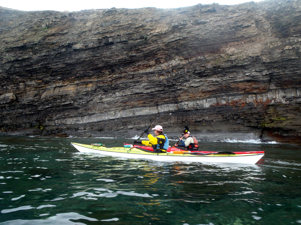
After our tour of the resettled community of Mosquito on Great Colinet Island we got back in our kayaks and paddled south along the east shore. Not long after leaving Mosquito the shoreline began to look more imposing. Some of us paddled close to the cliffs where there was a little action created by the wind waves.
We passed by several caves.
Pushed by the wind it wasn't long before we were at the south end of the island and the entrance to Wild Cove where we would ...
... set up our tents and become ...
... the largest and only community on the island.
There is a good reason the place is called Wild Cove. It is open to the south with unlimited fetch from the south. Next stop south from here is Bermuda, if your lucky to hit it. With that in mind we carried the kayaks well up onto the high beach plateau.
After the tents were set up and kayaks secured we went for a hike to the south headland we had passed to enter the cove. All along the high ground the tuckamore was evidence of how strong the wind can get. Tuckamore is a Newfoundland term for stunted fir and spruce trees that grow low to the ground and lean away from the direction of the wind. The strong wind stunts their growth as can be seen from the thick trunk but its low height.
Near the headland and looking back into the cove where our tents stood the land was a sea of yellow buttercups and reddish sorrel.
Our group at the headland minus Rob who had gone earlier for a run.
Back from the headland in the distance, it was time to get supper going.
The sun began to set and it got noticeably cooler so we set about collecting some wood for our camp fire. As the fire grew and the temperature fell the group ...
... crowded closer to the fire.
We took turns tending to the fire. People drifted away to their tents as the night wore on bringing an end to our first day at Great Colinet Island. It was good night Irene.
Monday, July 11, 2016
Great Colinet Island (2016) Part 1
Paddle Newfoundland and Labrador's introduction to kayak camping trip happened this past weekend (July 9 - 10) on Great Colinet Island. We met at 9:00 to convoy out to Admirals Beach in St. Marys Bay where we carried the kayaks to the water's edge and began to fill them with the necessities for camping.
The weekend started off with a bang. A beluga had been hanging out in the harbour for a couple of months. As we got on the water and floated waiting for everyone to launch it swam around checking us out. It wasn't chased or harried. We shared a mutual curiosity about each other.
Finally, just after 11:30 a flotilla of 16 kayaks set off across on the short crossing to Great Colinet Island.
Dean and Hazen led the trip. Our first port of call was the location of the resettled community of Regina (pronounced locally as Regeena) where, at 12:30, it was close enough to lunch time to have a bite to eat.
Leaving Regina the next destination was the resettled community of Mosquito. We had a little wind and following sea that pushed us along under bright blue skies.
We had the good fortune to have Sarah as part of the group. Some of Sarah's ancestors were from Mosquito so she was familiar with the history of the place. She showed us around the cemetery and pointed out the location of the community church. I had been here several times before and completely missed the outline of the former church hidden in the trees.
Now, Mosquito is the subject of one chapter in Scott Walden's book "Places Lost - In search of Newfoundland's resettled communities". Here Sarah kneels next to the headstone of her great grandfather Casimir Doody. I asked her to pose because I just thought it was appropriate and sort of a circle closed. As chance would have it Walden has a picture of the same headstone of Casimir Doody on page 94 of his book but without the growth that surrounds it now.
The census of 1921 shows Casimir was born in 1897 and married to Sarah, living in the household of father Bernard with a 7 month old son Brenard (typo in census??). So, Sarah, kneeling told us she was named for her great grandmother.
We walked through the heavily grown over graveyard reading the names and dates of death until we came to the old entrance. When I was here previously I thought the stones set in the pillars were decorative but there was a significance to the design and placement. Sarah explained there were 33 stones set in each face representing the age of Christ at the time of his crucifixion.
Walden's book has a picture of the entrance also on page 93 with the gate still hanging. It is now unhinged and standing beside the pillar on the right.
The graveyard is on the hill behind us. On our walk back to the beach where our kayaks were Sarah showed us the foundation of her grandparents' house. The 1921 census lists 45 souls living in 11 households. Casimir's family by 1935 had grown to 9 - 4 sons and 3 daughters (Eta, Agnes and Ellen). One on them must have lived here.
The surprising thing about the resettled community is the amount of open space that had not been reclaimed by the trees. Preparing to leave, I took a parting shot looking over the water towards Admirals Beach. Again, I was in step with Walden as he has a similar picture of the same tree on page 101.
These resettled communities are a favourite kayak destination for me. This time with Sarah whose explanations and comments put Mosquito in a new light.
Next stop, Wild Cove on the south side of the island where a city of 16 tents would spring up.
Friday, July 8, 2016
The paper chase
Saturday Dean, Hazen, Neville and Terry were going to take a test to determine whether they met Paddle Canada level III competencies. If they passed that would open the path to do their level IV in August. With that in mind Dean and Hazen wanted to make sure they were prepared so they, along with Brian, Cathy, Gary and myself, met at St. Philips on Friday to do some rescues etc.
Here Hazen comes to the aid of the damsel in distress, Cathy but ...
... she also knows how to get a rescue done, rescuing Dean. Its important not only to know different rescue techniques as the rescuer but also as the rescuee so when it happens it goes with the minimum of discussion. Everyone on the same page.
With everything under control, we went for a short paddle.
It doesn't hurt to have someone as knowledgeable as Brian around too when practicing any kayak skill.
Cathy in lime Rikki.
My favourite passage and a good place for a swim rescue practice.
Gary. Somewhere along our paddle Cathy and Gary hatched a plan to do a one night kayak camp trip to Kellys Island. The subject of three previous posts. I couldn't resist so I joined them; it was a blast.
A short break and stretch before finishing the day.
Saturday Cathy, Gary and I went to Kellys Island.
Dean and Hazen went to Placentia and passed their level III evaluation. They're on to Burgeo in August to do their level IV. Good for them because I paddle with these guys and I will feel a lot safer when they get the highest level kayak course offered by Paddle Canada. Me, I'll just be uncertified but certifiable *lol*
Wednesday, July 6, 2016
One night on Kellys Island (Part 3)
We hit the sleeping bags around 2:00 am. I awoke 6:00 ish and lay looking at the roof of my tent for a while before getting dressed and packing drybags and stuffing the sleeping bag into the compression bag. Then I quietly unzipped the tent door and looked out upon the world and the start of a new day.
There was no sign of Cathy or Gary so I went on walk about but Cathy, as it turns out, had already been out. I saw footprints through the grass. I looked back at our tents between the two trees, took a snap.
At the cliffs edge I looked back at the tents of Ant City perched 30 meters above the water of Conception Bay. I ...
... zoomed to catch the tents on top of the cliff and the kayaks nestled in the grass just above the beach. Click to enlarge for the full effect! A bit of a climb to lug the tents up but well worth the view.
We took down the tents and carefully making our way down the steep cliff face carried our gear down to the kayaks and readied to return home.
Not content with a straight line, rapid return we paddled around Kellys Island alongside the gently dipping sedimentary beds. Along the way we noted numerous places where rocks clung precariously to the cliffs threatening to fall on any unwary paddler. We stay off a bit just in case.
Nearing Easter Beach we were ready to begin our short 3 km crossing back to Long Pond. Paddling into a slight headwind we made the crossing in 30 minutes making an average of 6.0 kms/hr. Cathy and I exchanged knowing glances off and on; I was impressed with the speed she kept up. Rikki cut through the small wind waves like a hot knife through butter.
Red ... Right ... Return. At the red buoy we stopped for several minutes before entering the harbour. We drifted slightly towards the green buoy which made us look slightly ignorant of the rules when a large craft came up behind us. Oh well! Image is not everything.
Back in the industrial complex of Long Pond and back to civilization.
Twenty-six hours earlier our bows were pointed away from the beach. We were back from our one night camp trip to Kellys Island. It was a short 26 hours but we packed so much fun into those hours that it seemed a much longer trip.
It was a nice break, speaking for myself, as I had spent a frustrating time hooking home to town services. I felt refreshed (*lol*; private joke between ourselves) and ready to take on the world. This trip shows its not necessary to go far afield to get in a super night, not on the town, but out of the town.
Thanks Cathy and Gary for a most memorable trip and a thousand laughs.
Tuesday, July 5, 2016
One night on Kellys Island (Part 2)
In part 1 Cathy, Gary and I left Long Pond for Kellys Island where we set up the tents and left some of our gear before paddling the 5 kms to Bell Island to explore.
We paddled over to "The Bell" which took us further away making the bee line paddle back to Kellys a longish crossing of 6.5 kms. The wind had picked up and without working at all we did the crossing in 60 minutes. Then it was time to try and catch our supper.
For my friends who are not Newfoundlanders, a short backgrounder. In 1992 the cod stocks on our Grand Banks had been decimated by over-fishing. Canada totally mismanaged the resource and was forced to shut it down. At one time we could catch cod whenever we wanted to but during the "cod moratorium" we weren't allowed to catch even one for our own use. While the resource is making a comeback its not enough for a large commercial fishery but thanks to the big hearted crowd in our nations capital we're permitted to catch 5 cod per person each day.
Cathy brought a jigger so we could try from our kayaks.
Cathy and I rafted up and threw the jigger overboard. She spooled off I don't how many feet before it hit bottom. She pulled it up sightly and began "sawing" away. The jigger is pulled up and let sink repeatedly in the motion of a hand saw and with baited breath we waited for that tug on the line signaling we had one.
Repeated attempts yielded no reward so we pulled the jigger in having only sent it on a swim and headed for our campsite.
We were perched on a 15 meter hill overlooking Conception Bay. We could have camped on the beach but we liked the view from up on high so we carried only what we needed (tent, sleeping bag, thermarest, etc) to populate what we called Ant City. The rest of the stuff we left ...
... one the beach where happy hour ensued before ...
... supper.
After supper I gathered what wood was on the beach and we had a fire, not a large one but as large as we could make it with the limited amount of fire wood. It cooled down considerably as the sun began to set behind the cliff above our heads where the tents were set up. We decided not to open the bar until the fire had burned down and we had climbed safely up to our lofty perch.
The wind that was gentle at sea level accelerated up the cliff face and blew quite strongly where we had camped. Cathy's tent had two doors so the three of us sat looking out the back door and out of the wind. We played guessing games and laughed so hard my sides began to hurt.
Eventually the wind dropped, thankfully, and we moved to sit in the front door. Four kilometers across the water the lights of Conception Bay South filled the horizon. Cathy got a craving for Cheezies and I suggested pizza. She texted Dean to see if he would bring it out to us. We laughed some more and around 2:00 am we hit the hay.
A wonderful day full of adventure finished with a night of sound sleep. Good night Irene!
Monday, July 4, 2016
One night on Kellys Island (Part 1)
We've been to Kellys Island in Conception Bay numerous times. We checked it out for possible campsites and threatened to camp there. Its close by and ideal for a one night kayak camp trip.
Friday Cathy and Gary hatched a plan to bring that one night trip to fruition. I wasn't sure about the timing as my "To Do" list was extensive but I decided I needed to cross that trip off my list. We met at Long Pond at 9:30 to load up the kayaks for the 4 km crossing.
Leaving Long Pond we headed straight for the cobble beach where we would decide to either camp on the beach or on the hill 15 meters above the beach. We climbed the steep hill and selected a site for our tents. The plan was to set up the tents first, have lunch and then ...
go for a paddle.
On the northwest side of the island we set off for Bell Island. We took turns predicting the distance to a beach. Cathy had it at 4.2 kms, Gary 5.0 and myself at 4.7. The GPS read ...
... 5.2 when we reached the island so Gary won that one. But, there was no prize as we hadn't placed any bets.
The water was so clear and the sun so strong it made Cathy look like she was floating unsupported above the sea bottom.
Cathy wanted to paddle to the west side of Bell Island to the Grebes Nest so we headed west across the south side of the island under impressive cliffs reaching 50 meters in height.
At Freshwater Cove a short ladder up the hill attracted our attention. The day wasn't all about the paddle so we landed and took a short hike up following a small stream up a ravine. Further on we used a rope hanging down a slippery slope to climb onto ...
... a flat area with a great view down the ravine we named "Ant Hill Ravine". We walked a short distance with the hope of finding a pond the stream ran out of but we gave up. A subsequent review of maps and Google Earth showed the stream had no source in a pond. Good call!
By the time we continued our paddle it was 3:00 and getting too late to make the 14 kms round trip to the Grebes Nest so we agreed to go as far as "The Bell" of Bell Island. Here I named the two stone pillars "Homer" and "Marge".
Under crystal clear blue skies in Front Bell Cove with "The Clapper" on the right.
Cathy approaches "The Bell", a massive seastack ...
... standing off of Bell Island. We padled through in a stiffening breeze out of the north that increased in intensity squeezed between the two land masses. Around "The Bell" we rafted up and decided to make a bee line for Kellys Island and return to camp for happy hour and supper.
The game this time was to guess ho long it would take to cross the 6.5 kms distance. We each had a guess which turned out to be 60 minutes but we could have shaved 10 minutes off of that if we had wanted to as we got a good push in the following wind and sea.
Subscribe to:
Posts (Atom)