Translate

Showing posts with label Grand Bruit. Show all posts

Wednesday, July 14, 2010

Grand Bruit

Entering Grand Bruit

Ralph, Stan and I undertook a sea kayak trip from Harbour le Cou to Burgeo. It was part kayak trip and part living history.

I've been in a number of resettled communities but always many years after when the building had already crumbled and all that was left were foundations. Grand Bruit (pronounced "Brit") is the latest Newfoundland community to be resettled and this time I was on hand for the funeral.

While the residents voted to resettle, it did feel like a funeral to me and I felt in a way that I was intruding.

Landmarks

Grand Bruit has two landmarks: the church which overlooks everything in the community and the falls. If a third had to be picked, it would be how the houses are all crammed together around the harbour, so typical of Newfoundland outports.

In those houses people raised families, had dreams and shared sorrows. In those houses lived people who knew each other more than as friends but as extended family. People who worked and pulled together to make a living in an isolated setting.
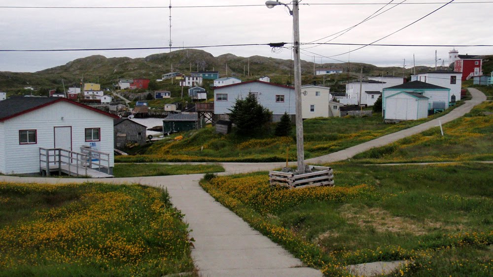
End of town

Looking east from the top of the falls the houses peter out. Near the center the closest green building is the oldest house at about 150 years old.

A working community

Lobster pots on this slipway attest to the fact that Grand Bruit was a working fishing community right up to resettlement. Some fishermen intend to carry on fishing out of other ports. Some will return here every summer during the lucrative lobster season because, while the residents have left, the lobster have not been resettled.

Quaint

Grand Bruit has been in the news recently over its resettlement but before that it was just another isolated community along the Newfoundland coast. It was just another name on the map and most, I suspect, never gave it a second thought.

Now that the community is dying, the province mourns the loss of yet another piece of its heritage. It was inevitable. The last students graduated from the elementary school in 2007 after which it was closed for good. The lifeblood of the community, its youth, began to drain away and its fate was sealed.

Connections

The community was connected by a concrete walkway that was wide enough for all terrain vehicles (ATV). While we were there the ATVs were busy carting household belongings from the homes to a storage building at the dock. There they waited to be shipped out on the local ferry service, bound for points west to Port aux Basques or east to Burgeo.

Along these walkways residents stopped to talk to each other. In the big city people look at the sidewalk rather than risk making eye contact with the oncoming. Here, doors did not have to be locked at night. People were connected not just by walkways, they shared a deeper connection.

Sentinels

The community is gone and all that's left are the buildings, the memories and the dead.

In maybe 50 years some other kayaker may happen upon this resettled community when all that's left are the concrete walkways and foundations and this cemetery. They may wonder about the people who lived here and what it was like to leave. I won't have to as I was here when the lights went out.

It unfortunately won't be the last time the lights get turned off. We should all share a sense of loss each time it happens.

Monday, July 12, 2010

Grand Bruit to Wreck Island

Stan ready to go - day 3

We slept in the church in the resettled community of Grand Bruit the previous night. At rise and shine we knew we had the weather with us again. A quick breakfast of porridge, kayaks repacked and we were on our way back to Burgeo. We would go far on this day.

Good-bye Grand Bruit

We had spent a considerable amount of time in Grand Bruit having to stop overnight to catch the ferry down to Rose Blanche and then again overnight on our paddle back up the coast. I got used to the place and had a number of enjoyable exchanges with the few people who were tying up loose ends before leaving the resettled community.

Grand Bruit will be left to decay like so many other resettled communities in Newfoundland. I've been in a few where the houses had fallen down and where only foundations remained. I wondered if I'd live long enough to come back one day to see only foundations - probably not.

Blue Hills of Grand Bruit

Leaving Grand Bruit the Blue Hills of Grand Bruit loomed over us in the distance. We originally planned a day hike but that may have been a bit optimistic but I'm sure the view from the top of there 400 metre high hills would have been impressive.

The water was calm and it felt like we literally flew over the surface as we made our way towards Sandbank Point.

Constant rocks and sunkers offshore

There were a lot of offshore rocks and sunkers for such an exposed and unforgiving coast.


Into Cinq Cerf Bay

Ralph's original paddle plan was to paddle into Cinq Cerf Bay and paddle inside of all the islands. At the bottom of the bay a salmon river ran out that on the map looked like it had potential to be a beautiful spot. We didn't make it. We did paddle inside of Cinq Cerf Islands, Shag Island but then outside of Blackhead Island to cross directly to Shot Bag Island and Long Point at the other end of the bay.

Looking for a rest stop

Having paddled through Cinq Cerf Bay we paddled around Long Point hoping to find a suitable place to take out for a rest. It didn't look good but as we looked across to Captain's Island we saw what looked to be a suitable beach so we carried on for almost another hour as the far away beach beckoned.

Caribou

A couple of caribou were on the beach at Captain's Island to greet me. The female and calf had come down to the waters edge for the salt water. They saw me and wandered up into the hills where a stag stood watching over them. These chance meeting are always a nice surprise.

We took out here for our first rest stop of the day.

The fog rolls in

As we sat having our snack break the fog rolled in. It was bright and I suspected the sun would burn the fog off after a while but we left Captain's Island in fog. Stan took charge of Ralph's GPS and led us through the fog around Smoky Island and Muddy Hole Bay. As we crossed Muddy Hole Bay the fog did lift to show we were on target for Muddy Hole Point. I could see bottom in the middle of the bay and thought how interesting this place would be in a sizeable swell.

Connoire Head

Connoire Bay was a crossing of 1 hour as we paddled directly across the mouth of the bay from Muddy Hole Point to Connoire Head. We swung around the Head and in pretty calm conditions and paddled towards Wreck Island. We were ready for a pit stop with over 30 kms under our hulls already on the day.

Paradise

As we came around the top of Wreck Island we were welcomed by this inviting sandy beach. More than a pit stop, we decided that we'd stay here for the night. The forecast for the next day was favourable which meant we didn't have to run in front of the weather.

Our Wreck Island home

Above the beach a level grassy field with a great view made for an ideal campsite. Looking back in the direction we came from I could see the Blue Hills of Grand Bruit and I marveled at how far we had paddled. Actually, I was astonished how far away the hills looked.

A strand of sand

We had a beautiful sandy beach to call home on Wreck Island.

Burgeo is that-a-way but well over the horizon. We sensed the the trip was winding down.

Fire on the beach

Our bellies satisfied with supper we gathered some firewood on the beach and had a bonfire. Later as the fire died down Ralph made notes of the day's paddle while I played it over in my head. We went to bed contented with the day's activities and slept well after the 36 km paddle.

84 kms paddled and good weather predicted for the next day that would see us back in Burgeo.

Sunday, July 11, 2010

La Plante Harbour to Grand Bruit

A new day awaits

We awoke to glorious sunshine after camping in La Plante Harbour some 26 kms from the start of our journey in Harbour le Cou. There was still a bit of fog laying on the hills but we knew the bright sunshine would burn off any residual fog after breakfast.

We were taking our chances paddling this coast at this time of year but so far the gods were smiling on us.

In La Poile Bay

The plan on this day was to paddle into the bay to see the community of La Poile, cross over and paddle around in Roti Bay and into Grand Bruit.

La Poile

La Poile is a community of some 200 residents. Its isolated and serviced by the same ferry that serviced Grand Bruit. The ferry Marine Eagle can take 12 passengers; 4 seats reserved for Grand Bruit residents and 8 for La Poile. That results in some shoving and pushing to get on the ferry.

The brother of Ralph's partner taught here some 30 years ago and Ralph wanted to see the place. Turning away he said "Check that off the list".

Heading for Eastern Point

We had paddled some distance into La Poile Bay to see the community of La Poile. The original plan was to cross the Bay and up the eastern shore. Instead Stan picked a course directly aimed at Eastern Point so we did a diagonal crossing of about 6 kms.

Pit stop

Eastern Point at La Poile Bay is a headland where normally conditions deteriorate and they did slightly. It got a little bumpy but very manageable. Two hours into the day's paddle and we figured a stop was in order. We found this sheltered beach just before French Cove and opposite Jacques Island.

Inside Jacques Island

We had stopped for a break on the mainland in a passage between it and Jacques Island. To the right at the bottom of Jacques Island, Roti Bay opened up for our run into Grand Bruit.

In Roti Bay

Rounding the bottom of Jacques Island were were out in Roti Bay proper. Ahead of Ralph lay Gull Island and as we paddled along we could see the transmission tower on the hill by Grand Bruit. We were making good progress in the perfect paddling conditions.

Entering Grand Bruit

The sun was shining brightly as I entered Grand Bruit just after 1:30. It was hard for me to fathom that I was back already given the length of the ferry ride out. The saying "The longest journey starts with a first step" is so true. Almost 50 kms one paddle stroke at a time.

The building clouds foretold of changing conditions and we were onshore only a matter of an hour when the winds picked up. Out on the bay where we had just paddled the wind had created many whitecaps. We were done for the day.

Centerpiece

The church is the centerpiece of most Newfoundland communities. Its usually positioned on a higher piece of ground and acted as a beacon for fishermen returning from the fishing grounds.

Grand Bruit has two - the church and the falls.

The water of a freshwater lake behind the community spills over a ledge that's about 15 metres high. It and the church behind are an awesome spectacle to see as mariners enter the harbour.

Room at the Inn?
Ralph chats it up with Joe, proprietor of the Cramalott Inn. I don't know if he's trying to check in at the wharf but it turned out the three of us stayed in the community church for the night. We were in good hands! It was a unique opportunity and meant a lot of our gear could be left in the boats making for an early departure the next morning.

A shortish paddle of 22 kms on this day for total of 48 - almost half way.