Translate

Monday, October 21, 2019

Paddling in the lun


Sunday the forecast was windy; 17 knots west gusting to 23 knots.  We are blessed with outstanding ocean scenery but cursed by topography.  The prevailing winds are SW and W and with many of the bays facing east, it leaves few options.  One I considered was a paddle along the east side of Bell Island.  So, Sunday Jenn and I caught the 12:10 ferry to Bell Island from Portugal Cove. A short ride to the nearby beach and we were at the put in.


"Lun" is Newfoundland vocabulary for a quiet protected place.  It was where we were in the wind shadow under cliffs rising 75 - 100 meters above the sea here approaching Green Head.


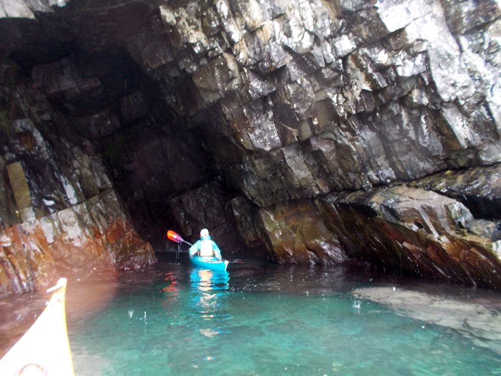
Water trickled down in places; we passed by the one sea stack as we paddled northerly.


The distinctive cliffs at Long Harry.


Passing Polls Head we entered the wide sweeping cove with a good example of the structural geology of Bell Island.  Here a wide bed of brownish grey sandstone interbedded with darker shales shows the beds strike northerly and dip easterly.  That is to say, they slant from left to right and dip away from us.


Near Eastern Head we looked through this tunnel into a cove on the other side of the teardrop peninsula.  Jenn and I paddled a bit further past Eastern Head to stick out our noses where we felt the strength of the wind.  We decided to turn around here and ...


... head back in a southerly direction.  We passed by the beach where we put in as there was more protected coast to explore.  Here we were at Dominion Pier, one of two iron ore offloading locations.  Continuing on we reached the nearby ...


... Scotia Pier.  The oolitic hematite was first recognized as iron ore around 1892 though ships used the ore for ballast for the return voyage to Europe for decades.  The Nova Scotia Steel and Coal Company acquired mining rights shorty after 1892 and Dominion Iron and Steel Company in 1899.

The iron ore beds dip east with underground mining running some 3 kilometers offshore and 500 meters below sea level.  The mines produced 48 million long tons of ore before being closed down in the late '60s .  Estimates of 10 billion, yes, that is with a capital B, tons remain, however, the cheaper cost of surface mining at other locations makes it uneconomical to mine.


We carried on some more with an eye on the clock and the arrival times of the ferry for the return.  Here passing a waterfall and ...


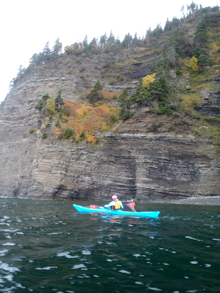
... the ever present trees clinging somehow to the cliff faces, some in fall colours.

We agreed to paddle on another 15 minutes which put us close to Lance Cove where we turned around to catch the 5:30 ferry back to Portugal Cove.  I failed to conscript any of my paddling buddies but Jenn and I made the most of a questionable paddling day.  We were well protected from the wind which we did feel from time to time but nothing to cause us any difficulty.

Jenn is a visiting artist-in-residence from Nova Scotia.  We've managed four paddles in the six weeks before she leaves next weekend.  If this is the last paddle we do, I think it was a nice way to cap off her Newfoundland visit.

Saturday, October 5, 2019

Avondale with a twist


The usual paddle in Avondale is to stay in Gasters Bay paddling either clockwise or counterclockwise.  On Friday with Eleanor and Jenn who were visiting from out of province we began our paddle down the east side towards Salmon Cove Point but after that we left Gasters Bay for Harbour Main.


From the put-in the shoreline is either steeply forested or low laying with scattered trees.  Its a paddle but not necessarily to awe.  Jenn spotted a white bucket floating in the water; it was to become her constant companion for the day along with other "ocean treasures".


On the west shore at Bacon Cove is a well known unconformity where Cambrian age rocks lie on Precanbrian, Protorzoic rocks. Here a block of red Cambrian rocks were faulted, that is, physically moved, against Conception Group siltstones.  The red staining was the result of hematite, iron, in the rock being oxidized in the rapidly oxygenating atmosphere of the time.


The lower laying forested shore gave way to more dominating cliffs as we approached Salmon Coe Point here ...


... made white by the guano of nesting birds.


Whereas we had small wind waves until we got to Salmon Cove Point, we then felt the effects of a swell running out of the north at the Point.


Looking south and admiring the swell crashing over the rocks.


We rounded the Point and were in Harbour Main.  The slot at the Point was a no-go zone.  This picture is not worth a thousand words for it doesn't come close to the action there.  But, it is worth a few to say that as swell hit the Point, seconds later it surged through the slot from both sides meeting in the middle and spraying meters into the air.


On the Harbour Main side the imposing cliffs sheltered us from the westerly wind.


A cave to explore that ...


... is open at the far end.  I've spent enough time in the cave so I lay back happy to see Eleanor and Jenn enjoy the spectacle of water surging into the cave at the far end.  Only at the high point of tide and calm seas do the rocks at the far end offer an opportunity to enter there.

After some minutes the three of us moved further down the shore to find a beach for a break before returning uneventfully to Avondale where ...


... the scene looking down the bay as we got off the water was a payoff and conclusion to a thoroughly enjoyable day in kayaks.

Tuesday, September 24, 2019

A bit of everything in Bay Bulls


The forecast for today was winds from the north at 20 kms, gusting to 40.  I suggested a paddle in Bay Bulls.  A paddle along the north side of the harbour would moderate the affects of the wind.  Jenn and I met shortly before 10:00 in Bay Bulls with not a breath of wind apparent.  So we set off along the south side knowing that should the predicted wind materialize we'd just cross over to the north side.


Exploring the world from the bottom of a cave.  First I had a turn, then Jenn and then further on ...


... another.


Investigating this rock to paddle around but ...


... not this one, another one.


As we paddled east along the south shore we reached and went around Big Cove Point and the open ocean all the way to Ireland.  From the put-in we had paddled east, first past black slates of the St. John's Formation and then the greenish grey sandstones and, here, the red sandstones of the Signal Hill Formation.


A whispy waterfall fell from above where both Jenn and I grabbed a shower.


The wind waves began to grow as the wind began to pick up.  But, we had come this far and I wanted to show Jenn some of the Baboul Rocks so we paddled south among them and sheltering behind one to have a quick snack.

The forecasted north wind was more NE as we left Babou Rocks.  We set out for the north shore of the harbour into a stiff wind and breaking waves.  We paddled side by side across the 2 km open mouth of the harbour with occasional waves breaking over the kayaks and plastering us with salt water.

The trick is not to look at the destination but merely just paddle and eventually ...


... there's an assurance calmer waters will be reached.  Water drops on the camera lens testify to salty spray.

We paddle around Useless Bay, past Bread and Cheese Point and 4.5 kms later we were back at the take-out.

It was a bit of everything - caves, rocks, open ocean paddling and calm inner harbour waters.  I knew Jenn was a good paddler as I was so told.  Today she proved it; huge respect!

Saturday, September 14, 2019

Making a new friend


Some years ago friend Eleanor from Nova Scotia visited our province and we shared a paddle with her in Cape Broyle.  Recently Eleanor contacted me to say a friend of  hers would be in the province for six weeks.  Today Cathy, Gary and I met Jenn for an introductory paddle.


As I didn't know her I thought we should be flexible for our first paddle as to distance.  We had two targets in mind.  Reaching Portugal Cove we could decide whether to extend the paddle further up the coast or turn around there.


Gary approaching Portugal Cove where we ...


... can paddle through Two Tower Passage between the vertical cliffs and ...


... an offshore outcrop that provides protection from breaking waves.


Satisfied everyone was doing fine we decided on paddling a little farther.


We explored this cleft and cave and were content to make this our turnaround point.


Returning to Portugal Cove we got out to stretch our legs on this beach and also decided to clean up and remove various bits and pieces of plastic flotsam.

After getting out of our paddling gear the four of us stopped for a choice of coffee or tea and a nibble of fries etc in the warm sunshine.  We chatted for some time and left having made a new friend.  I'm certain we'll have more opportunities to show Jenn some of the other kayaking hot spots on the Avalon Peninsula of our province.  That's the kayaking community for ya wherever ya go!

Sunday, September 8, 2019

Beating Dorian to the punch


Those reading from North America will be very familiar with Hurricane Dorian that decimated the Bahamas earlier this week.  It lashed the east coast of the US as it made its way north and was due to arrive in Newfoundland on Sunday.  A club paddle out of St. Philips was squeezed in on Saturday before it arrived.

Eleven paddlers showed up to enjoy a sunny and calm day on the water.


It was a short paddle of 10 kms to Portugal Cove along a shoreline in shadow with the sun to the est.


While it is a short paddle there are numerous rocks that can be paddled around that add to the entertainment value.


I lurked behind rocks to catch different members of the group as they passed by.


Its a paddle for me but its also about keeping my eyes open for photo ops.  Sometimes the other senses lose out during a paddle or a hike when the emphasis is on sight of picturesque scenes but attention to smell and touch is also important.  The sea has its own unique smells and the feel of water temperature on the hands adds to the experience.


Cathy joins me among these rocks.


At Beachy Cove the gang stopped to enjoy the sun's rays in front of the contorted rocks mangled by the heat generated by the Topsail Fault which defines the shoreline here.


An hour later after a relaxed paddle from St. Philips we came to Portugal Cove where we took out on a small beach to break up the paddle before the return to St. Philips.

Dorian arrived on Sunday but we had beaten its arrival with another super day on the water.

Thursday, August 29, 2019

Burgeo Day 5 - Foggy post rain paddle


There was no paddling on day 4, Thursday, as we had strong winds and rain.  Rain wasn't the issue however because Brian, Hazen, Sue and I went for a walk along beaches from our campsites to Aaron Arm.  Overnight it poured rain but by morning the rain had stopped after 40 mm had fallen.  It was foggy and damp when we got up.


Nine of us started the week.  Wednesday Terry and Sharon left.  Thursday Clyde hit the road and Friday morning Brian, Neil, Sue and Ysabelle departed.  That left Hazen and myself to figure out what we'd do on our last day.

We opted to retrace the route of our Thursday beaches walk.  After leaving a car in Burgeo we drove to Aaron Arm to begin our paddle.


The fog persisted but there was no wind.  It was great paddling and soon we were at the tickle leading out of Aaron Arm.


We stopped at the beach that was the end point of Thursday's hike.  I got out to get a picture of ...


... the mineralization on the surface of the large boulder.  The surface was covered by huge crystals of quartz and orthoclase feldspar.


Sandbanks Provincial Park is aptly named.  Most of the coast we paddled by were high sandbanks and where eroded, sandy beaches.


I recognized the point where we walked out onto another beach on a trail bypassing a rocky headland.


We were told we could access this part of the coast from our campsites by hauling our kayaks to the swimming hole in the park and then to Heron Pond and thence via a small stream.  When we got to where the stream meets the ocean Hazen and I decided to see how far it was navigable.  We were on a rising tide and made considerable headway but not all the way.  We did however ...


... reach a bridge that the waking trail goes over.  The tide had not reached its highest point and had it done so we were convinced we cold have gotten into Heron Pond.


Not all of the coast was sandy beach.  Here at Grip Head the massive cliffs cut one beach off from the string of beaches.


Three hours after leaving Aaron Arm we caught sight of the first houses of Burgeo.  We continued our paddle within sight of the houses of Burgeo, made our way up short reach and ...


... had a short chat with two sailors from the Netherlands.  I had spotted the red, white and blue flag on the sailboat from the ferry to Ramea on Wednesday as it sailed west and wondered if I'd have a chance to meet it and get the story.  They had sailed the Atlantic and were on their way to Chesapeake Bay in the USA.

Several minutes of practicing my rusty Dutch, Hazen and I moved on and took out at the fish plant, stowed our gear, drove to Aaron Arm and picked up Hazen's car.  Here's the track for the day.


It was just Hazen and I by the fire on our last day at the park.  We burned all the remaining wood we had and had a few swallies.  Saturday morning I was up early to break camp, have breakfast and begin the 900 km drive home.

It was a super week doing something every day.  Thanks to Brian for instigating the trip and Clyde, Hazen, Neil, Sharon, Sue, Terry and Ysabelle for sharing the adventure.