Translate

Wednesday, July 30, 2014

Fortune Bay return


All good things must come to an end and so it was on the seventh day of our Fortune Bay trip.

It was windy all night and so it was when we got up on Friday morning.  We listened to the marine forecast and discussed the options as we watched whitecaps on the water in the protected cove we were camped in.  We took our time with breakfast while our indecision simmered.

As we finished breakfast it seemed like the wind abated a bit so we decided to break camp and stick our noses out past Lobster Cove Point.  If it looked safe we'd carry on.  If not we'd come back and pitch the tents again.


Things looked OK but sizable.  The saving grace was that what wind there was would be behind us.  There wasn't much wind but the sea continued to run with 1 - 1.5 meter waves.  Here's a short 1 minute video of conditions at Friar Head.  Practice at St. Philips was paying off.


Looks smooth but looks are deceptive.  I put on a burst of speed to catch Dean and Neville and the sea stack, just barely.  Funny thing was when we passed Friar Head there was no discussion of whether we should go back.  In my mind there was never any doubt we were going.  While some waves broke over the kayak it was exhilarating paddling.


At Conne Big Head the land turns and we had protection from the larger waves but only while we were in Big Conne.


At Tranmer Cove we were in it again and the first hour was behind us.


An hour later we were in Wild Bight and the entrance to the resettled community of Femme.  Things were calm as Petticoat Island to starboard provided the protection.


Near Femme we stopped to stretch our legs and a snack.  It continued foggy and grey as we exited back out into the bay between Petticoat Island and Red Cove.


At Fish Rock near New Harbour we set off into the fog to cross over to Bay L'Argent.  Somewhere over there lay land, beyond our compass bearing of 130 degrees.


We kept paddling in the beam sea and sure enough land began to appear.  To be truthful, we couldn't miss because we would have hit land nywhere in the direction we were going but its comforting to know ...


... our navigation skills were up to the task.  The headland at Harbour Mille is dark on port and Bay L'Argent to starboard with the 1,000 foot beacon of Sugarloaf Hill right in front of my bow.


Neville and I arrive at Bay L'Argent just as skies were beginning to clear at 1:00.


Brilliant sunshine erupted while we unloaded the kayaks and prepared for the 2.5 hour drive home.  We were headed home but not before we had our traditional feed of fish and chips.

The trip was over.  We managed to clock 150.1 kilometers.  We had a bit of everything: sun, fog, rain, calm and wind.  That is to be expected on any week long trip.  I enjoyed every minute of it.

Thanks Dean, Hazen and Neville.  To Clyde who was part of the planning but had to bail at the last minute, you were missed.  Maybe next year.  Now, where are my maps!


The last leg!

Tuesday, July 29, 2014

Twenty-one kilometers to nowhere in Long Harbour


We awoke again on day 6, Thursday, to foggy weather.  We were in Lobster Cove in Long Harbour and had clocked just over 100 kms on our tour of Fortune Bay so far.  The plan for the day was a paddle up Long Harbour and back, leaving the tents in place.  Long Harbour is a fjord like indenture that probes almost 30 kms inland.

Without having to break camp we took our time and got on the water just before 10:00.


Just underway we came to Pissing Mare Falls cascading off of the 250 foot high cliffs.


The thing about fog is there is usually very little wind.  The water was calm an we were in no hurry what-so-ever.  We made our way slowly past the ruddy volcanic rocks of the harbour.


The entrance to Long Harbour began to disappear the further we delved into the fjord.


The harbour narrows at Tickle Beach in the distance but then opens up again.


As we past Tickle Beach we saw a red object in the distance.  The closer we got the more it came into ...


... focus.  Someone with a sense of humour had tied a Santa up in the trees.  We all got a good chuckle out of it.


At noon it began to pour.  It made no difference as we were in our drysuits and it wasn't cold.


At Indian Tea Island and ten kilometers in we crossed over to the west side arriving at Herring Island.  Behind it we found ...


... this small take-out where just wide enough to haul the kayaks out and cook lunch.


It continued to pour off and on so we erected a tarp crouched against the cliff.


I had filtered some water earlier in the morning but there was no need to get it out.  The heavy rain washing the rocky cliff trickled down and we had outside plumbing.


Looking back down to the entrance to Long Harbour it looked to be clearing up.  It did a bit as the rain stopped but it brought with in a bit of a breeze and from Tickle Beach it was a sprint back to Lobster Cove.  We were glad we had left the tents and the tarp up.


Looking out from under "Big Yellow" it didn't look like we were going to have our usual camp fire.  A driving drizzle was blowing into the cove so Neville took out a couple of glowsticks that served as a fire stand-in.  If my memory serves me well, I believe it was the first time in five years of kayak camping we didn't have a camp fire.

We were comfortable under the tarp and the bar was open.  Last call for alcohol was early though as we made a dash to the tents.  The wind and rain continued overnight and I wondered whether we'd escape Long Harbour in the morning to continue our tour.


The track into and out of Long Harbour.

Monday, July 28, 2014

The graveyard at Crants Cove


When you paddle around the point from Stones Cove the first thing that catches your eye is the massive hill and then the white grave headstones beneath it.  We got out at Crants Cove to have a look.


The community of Crants Cove is another of the hundreds of resettled communities of Newfoundland.  When the residents left, they left behind the history of the community as embodied in the white tombstones.


The graveyard is all overgrown with only the markers along the edges visible.  Somewhere in there many more are hidden.


A gagged line of headstones look out upon a sea where the livelihood of Crants Cove swam.


We had gotten out for a walk around Stones Cove before arriving at Crants Cove.  It was a barren, rocky place and we remarked that vegetable farming must have been impossible there are there was very little topsoil.  I walked farther inland to see if there was a graveyard because I was told there was one.  There wasn't.

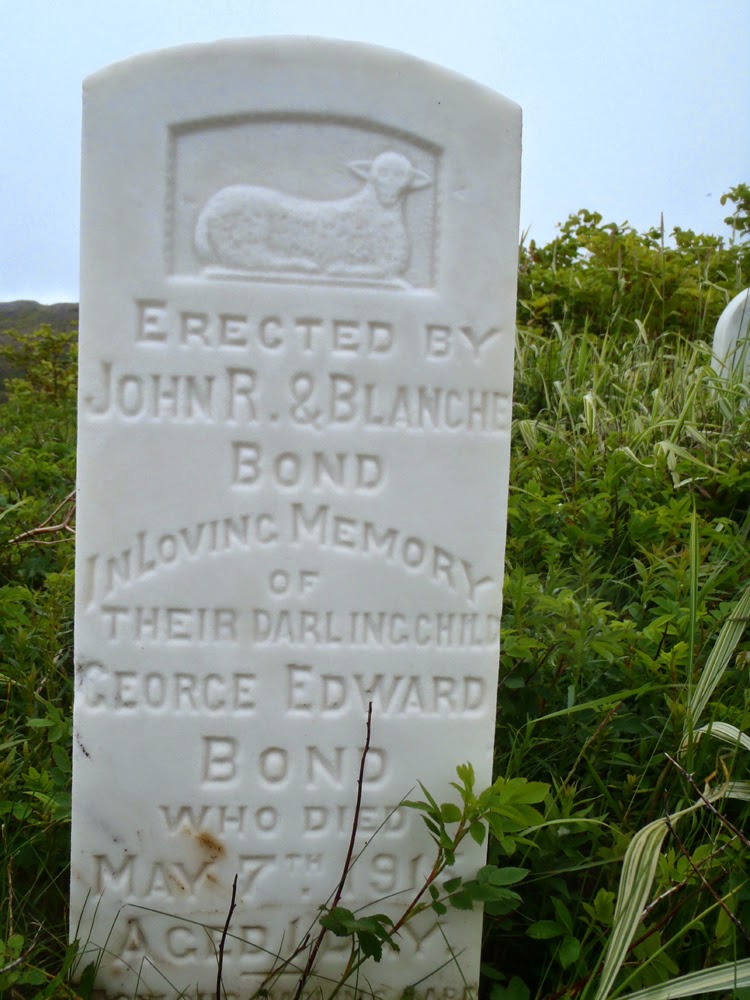
The mystery was solved though at Crants Cove.  I snapped some shots of the headstones to research them later at home.  This one marks the final resting place of Martha Thornhill.  A search of the 1921 census showed she was a resident of nearby Andersons Cove.


The Bond name is prominent in the census of Stones Cove.  A review of the 1921 census showed the parents of George Edward Bond, John R. and Blanche, resided in Stones Cove.  Their child George died in 1916 at one day old but the census indicated they had two other children in 1921.  It was  harsh place and if there were complications at birth there wasn't anything anyone could do to change fate.


Two more children of Thomas and Ida Francis of Stones Cove lie here.  Emily Ellen at eight days and John Robert at 6 1/2 months.  It had to be heartbreaking for the parents, the little lamb left for us to ponder how fragile life was without modern medical attention.


So, the mystery of the graveyard for Stones Cove was solved.  They and the residents of nearby Andersons Cove buried their loved ones in Crants Cove, the only place with enough soil in which to dig a grave.

As I walked around the outer edge of the graveyard I wondered what kind of life these people had.  There were dangers living in such isolated places but there must also have been great rewards.

The struggle for survival would have been tenuous with food coming from the sea and land.  Meat would have consisted of rabbits and caribou and vegetables probably consisting of mainly potatoes grown in the precious little soil.  Wild berries supplemented the diet.

They would have had a close knit community where everyone pulled together and while they had worries, they didn't have some of the worries we have today.  I suspect in many ways they were more carefree.

Those people are gone and their descendents scattered who knows where.  I wonder if any give a thought to the those left behind on that barren outcrop of land very few people visit anymore?

Sunday, July 27, 2014

Looking for the Stones of Stones Cove


On our way to Lobster Cove in Long Harbour we stopped at the location of the resettled community of Stones Cove.  First we cooked lunch and then Dean, Hazen, Neville and I had a look around.  All that's left of the community are concrete foundations and a some rotting lumber.

Here, a set of steps must have led into a house.


Concrete monoliths stand alone now in the grass where once a community of almost 200 persons lived.  The census for 1921 listed 191 persons living in 36 households.


Here lie the remains of the community church.


Another remnant of pillars and notches to accept the wood for the structure above it.


Some of the more numerous names found on the census include Elms, Bond, Pope and Hatch.  But, oddly enough, no people with the name Stone.


This house was well up on the hill with a fine view out over the cove.


This was the only building with rotting wood still laying around.  My guess it was the old schoolhouse.


A lone marker stands guard over the former community.  It was erected in loving memory to John T. Price who was 29 years old when he drowned off of Long Harbour Point on November 8, 1911.


This is an old photo of Stones Cove taken by E.H. Vokey on September 14, 1939 from the book "Places Lost" by Scott Walden.  Its a must read for anyone interested in resettled Newfoundland communities and I highly recommend it.

Walden writes " According to local lore, Crants Cove was settled in the very early nineteenth century by two families, the Crants and the Stones.  After a forest fire cleared trees in a nearby cove, the Stones moved over the separating hill to what came to be called Stones Cove."

The Stones must have moved on because none were listed in the census of 1921.  There are no Stones there now, only rocks.  Another settlement with its memories lost to history.

Saturday, July 26, 2014

Return to Lobster Cove


On the fifth day of our Fortune bay trip we departed Rencontre East in fog.


Rencontre Lake is some seven kilometers long and runs out into the sea near the community.  At high tide it is possible to paddle over the falls an into the lake but the timing of the high tide was off when we arrived.


The fog couldn't hide the rugged beauty.


We handrailed along the coast and reaching Big Head we made a short crossing to the other side of Mal Bay.  Near Mooring Cove it started to rain heavily and the wind came up.  We had decent weather in the four days up to that point so we were lucky to have gotten into day five before it turned inclement.  Such weather is to be expected on longer trips.  It didn't matter as we were in our drysuits.


The rain eased but fed streams falling off the cliffs on the west side of Mal Bay.


We exited Mal Bay at Woody Head where we were exposed to seas that had built up by the southwest winds.  For an hour and a half we rode one meter seas until we reached Stones Cove where we got out to have lunch and look around.

Stones Cove is a resettled community (more on that later) that at one time housed almost 200 persons in 36 households.  We climbed high on the hills above the former community and had a great view of the cove.  After looking around at the various foundations of the former community we headed back into the whitecaps ...


... made another stop at Crants Cove to have a look at the cemetery before ...


... rounding Long Harbour Point and the relative safety of Long Harbour.


We reached Lobster Cove in Long Harbour at 3:00 to set up camp on the hillside overlooking the cove and in the protection from the southwest winds.  Five years ago Stan and I spent a windy night here on the exposed bank in the middle of the cove.  This was a much better site that Neville though might have been a potato garden many yers ago.


We set up Dean's ubber-tarp he has dubbed "Big Yellow".  Dean and Hazen relax after the bar was opened.


It felt good to be back in familiar surroundings under the protection of "Big Yellow".  It wasn't raining; it was only foggy.  We all agreed the yellow in the tarp brightened things considerably.


The orientation of the cove meant all the wood was in the farther side so after supper we walked over with our wobbly chairs and bar supplies to have our usual campfire.  We planned on a two night stay so we had to reserve some wood for the second night.  Conservation of the wood meant I would take no part in the fire on this evening.


Here's our 21 kilometer track to Lobster Cove from Rencontre East with the last bit along the exposed coast.