Translate

Saturday, November 19, 2016

Neither snow nor rain is an excuse


The forecast for today was heavy rain.  Some of our paddling friends had reasons for not paddling and two of the guys paddled closer to home.  Dean, Shane and I drove the 70 kms to Cape Broyle for our weekly fix.


We have had a lot of rain recently as was evident when we arrived at the terminus of Horse Chops River.  There was a good flow of water at the falls.


Shane examines a small anticline, an downward facing warp in the sedimentary rocks.  I'm not sure if he realized what we were looking at but at least he knows now!
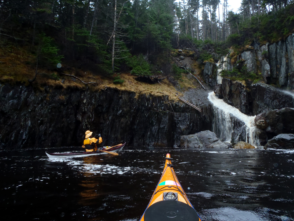

There was water running everywhere.  So far we hadn't run into the torrential rain.  I wondered when it would start.


The further east we paddled the more massive the cliffs became.  Here the lines separating the sedimentary beds are highlighted by growth of vegetation in places.


Cape Broyle is a beautiful place to paddle, even in the rain, but this tunnel is my favourite feature.  When Shane suggested the day's destination I checked the tide tables.  It was going to be near high tide while we were here so I knew it would be accessible.


There are also numerous caves in Cape Broyle harbour.  Nearby, I entered this cave and caught Shane at the entrance.


At Freshwater Cove we saw our largest waterfall for the day.


We entered Lance Cove with is offshore sea stack.  This is usually the turnaround point for club paddles but we didn't stop there, instead crossing through the cove on our way to Church Cove where we planned for lunch.  Between Lance Cove and Church Cove there are ...


... numerous off shore rocks.  Deep in the harbour it was calm.  Further out we started to feel a bit of swell which made for more interesting paddling.


We arrived at Church Cove and took out for lunch.  If the truth be told, it wasn't fit for man nor beast.  Except us.  It was raining and resting for lunch the chill began to set in.  Dean and I had our cags which made it pleasant enough as we were entertained by a half dozen or more seals.


After lunch the sea state changed dramatically building until we ...


... paddled out into the open ocean past North Point where it was huge.  Some swells had long wavelengths but volumes of water.  Interspersed were breaking waves of 2 meters that, when paddled over, caused a precipitous drop and plop on the down side.  Dean got a better shot of the conditions on his blog.

We were surprised by the change in conditions and by its effects that were felt a full 5 kms into the harbour.  It wasn't until we were past Gentlemans Cove that the sea flattened again protected by Brigus Head at the north entrance.

So, for 5 kms we had some great surfing and then a relaxed paddle back to the take-out where hot coffee and soup waited for us at the Riverside Restaurant.

Awesome day guys!  Thanks.

Wednesday, November 16, 2016

Super paddle under the supermoon


Now for something different.  A night paddle under this month's supermoon.  We (Brian, Cathy, Dean, Derrick, Gary, Neville, Shane, Sue, Terry and myself), arrived in total darkness and carried the kayaks to the slipway.


The kayaks are readied under the glow of a light thanks the harbour authority.


There wasn't room enough for the ten boats so the front lined up boats put in to enable everyone to get on the water.


Just before 7:00 we we all on the water and ...


... ready to go.  There won't be much scenery in this post, only my friends seemingly suspended in the inky blackness.  The moon had not yet risen at the time we put in.


While the pictures show an inky darkness and while the moon had not yet risen, the actual conditions were much lighter.  The moon lit up the sky announcing its imminent arrival and the sea was a steel grey colour.  We each had glow sticks so that we could keep track of everyone on the water if we got too separated.


Minutes after 7:00 the moon rose over the low hills to our left.  The dot hovering in the dark is the moon and the best the camera could do so I scammed the following image from Google images.


The moon averages 384,000 kms from the Earth.  Because the moon's orbit is elliptical, it is closest at what's called perigee.  This month its distance is 356,500, the closest its been since 1948 so we were determined to mark it with a moonlight paddle.  As you can see, last night it was 14% bigger and 30% brighter.


We arrived at Topsail Beach to stretch our legs under the moonlit night.


We all agreed to bring some wood so we could have a little fire.  It was unseasonably warm for November 15 but the fire was appreciated anyway.  It served as a focal point to stand around and chat.


Topsail Beach is car accessible and as we left some turned on their lights to see what the lights were on the water.  They were seeing our glow sticks.


The super moon, technically called a perigee moon, wasn't the only attraction on the water.  The bioluminescence was spectacular not unlike the sparks flying from a grinder on metal.  Sparkes flew from the bow as it cut through the sea and also from each paddle stroke pulled through the water.


At 10:30, three and a half hour later we were back again cruising through the channel into the harbour.

It was by all accounts a super fantastic night, a nice change of pace.  It will be some job to keep this paddle of my list of top 10 paddles for the year.  Thanks to everyone for a most enjoyable night.

Monday, November 14, 2016

Noah's Ark - Update


On August 3rd we met in St. Philips for our usual Wednesday evening practice.  It was calm so we went for a paddle to Portugal Cove.  Along the way we came upon this contraption of a boat.  We had no idea who owned it or how it came to float here.  It was taking a good pounding on the rocks and some of the boards had come off floating in the water.


We checked to see if anyone was aboard, dead or alive, but there was no one.  We went on and a week later we paddled the same shoreline but the floating object was gone.

Imagine my surprise when I saw a CBC Newfoundland article online indicating it has washed up in Ireland recently.  Here's a link to the article.  Good for a chuckle for sure!

Friday, November 11, 2016

14.3 Squared


Today was Friday, Remembrance Day, 2016.  On a grey cloudy day Cathy, Gary and I arrived at Tors Cove to paddle to the abandoned community of La Manche.  It was supposed to be windy but it wasn't when we arrived so ... on with the plan.


We put in and headed south inside the islands of the Witless Bay Ecological Reserve.  The Reserve is home to 10's of thousands of sea birds but they have already departed for the winter to live on the open sea.  Here, inside the islands we were protected from the open North Atlantic and I mean open.  Open all the way west to Ireland.  But, as we paddled south we lost the protection of the islands and ...


... it got lumpy.  Lumpy and confused with waves we had to climb over and ...


... down.


All along the shore where the sea ended, it ended in foam.  There were places it went 5 - 6 meters into the air but trying to catch that and stay upright proved to be hit and miss.  Actually, miss.


The water all along was a mass of peaks but we stuck with it and soon we were at Bauline Head and the entrance to La Manche Bay.  In the middle distance loomed Cape Neddick.


While we paddled south we were padding into the waves.  As we turned west into La Manche Bay we had it on the beam with occasional waves breaking over the deck.  No big deal and when we got further into the Bay and got protection from Cape Neddick the water flattened out as we cruised into La Manche with its scenic suspension bridge of the East Coast Trail.


As we paddled into the harbour we were greeted by two people on the bridge who shouted out that there were 7 or 8 seals by the falls where La Manche River runs out.  We went to look but the seals are elusive swimming under us and out into the harbour so we ...


... took out for lunch.  There's no beach at La Manche as can be seen from ...


... old photo dating to 1966.  We pulled out onto the seaweed covered rocks just about where the white house is in the center of the photo.  Back up on the hill where the dark grey house is located we ...


...sat on the old foundation to eat lunch.


Cathy brought a bag of twigs and grass *lol* ha ha clippings. to start a fire and warm us before we got going again.  There was no wood around to add so it was a pretty modest fire but we convinced ourselves we were warmed.


As we got in our kayaks to return to Tors Cove one of the seals was hauled out on a rock (bottom center).  We weren't going to get close so we went on.

The conditions for the run back had not changed except we then had the waves to push us back.  At Tors Cove I checked the GPS.  It read 14.3 kms.  Not a long paddle because we had to stay offshore but the conditions made it seem much longer; at least squared.

Thursday, November 10, 2016

Deja Vu

I think I've been here before!!!


On Tuesday Brian and I paddled from St Philips to Topsail return.  Invitees Hazen and Pete couldn't come so Brian and I chatted as we made our way in small wind waves and weaving around rocks.  At one point Brian wondered if I kept track of all the times we've paddled this familiar shore.  I had no idea about the numbers off-hand.

I know we paddle there in the spring and when its windy.


I was curious so I checked Stardust's ship's log.  I started recording it in 2009.  For the first three years it was 8 times.

We paddle there in summer when its calm and warm.


In 2012 we paddled this shore 7 times and in the fall.


From 2013 to the current year, and the year is not over yet, the frequency of paddling the shore really picked up; a whopping 54 times in 4 years.

As you can, see we also paddle there in winter.

Its so close by and convenient.  Sometimes I don't feel like a longer drive but I need to get on the water.  St. Philips makes sense.

Sunday, November 6, 2016

The best laid plans ...


The best laid plans of mice and men often go awry they say.  But sometimes they don't.  I suggested a paddle from Colliers to Conception Harbour.  That gave us protection from NW winds paddling out Colliers Bay and have it behind us after we got around the peninsula heading down Gasters Bay into Conception Harbour.

The wind turned out to be westerly and light so we scraped the original idea and paddled from Colliers to Brigus return.  It proved to be a more scenic route.  The group of eight on the day's paddle were Brian, Cathy, Dean, Derrick, Gary, Shane, Terry and myself.


Leaving the beach we headed north on flat calm waters paddling under the hills of volcanic rocks of the Harbour Main Group consisting mainly of basalts, andesites and rhyolites.


Shane and Terry explore a crevice.


We arrived at Turks Gut where a fault runs up the valley separating the volcanic rocks from sedimentary rocks of the Conception Group.


The paddle up to Turks Gut was uneventful but beyond it got more interesting with a few sea stacks and ...


... places to grab a shower if so disposed to do so.


At this sea arch its clear to see we were now paddling along sedimentary rocks with its defined beds dipping from east to west.


A rocky sentinel stands off alone in the sea and ...


... another (I have no idea why the camera made this shot darker under the same lighting conditions) which, when we passed through opened up into a cove where the scenery dramatically changed to ...


... Lower Cambrian age red and green slates of the Brigus Formation.

Its a peasant surprise emerging from the slot guarding the shoreline entrance the first time I was here.  We were also here earlier this year and I knew what awaited but kept quiet to allow Cathy to be surprised.  This time it was Derrick, who has sailed past here before but because the sailboat runs further offshore, it escaped him.


The red rocks are laid down in shallow water allowing oxygen to essentially rust the iron hematite.  The green rocks indicate deposition in anoxic (devoid of oxygen) waters preventing oxidation of the hematite.  Though I have to admit some confusion where the red beds fade to green within the same bed.


We arrived at South Point at the entrance to Brigus.


Inside the point at Great Cove in Brigus Bay we stopped to play in a bit of wave action in the rocks.


As we continued on to what would be our lunch beach we spotted a minke whale.  It was feeding.  I paddled out from the cliffs a little into the cove where I noticed the water boil up around the kayak.  I looked down and while I couldn't see the whale pass under it had surely done so.  After that bit of excitement we ...


... pulled out to stop for lunch.  Those who brought coats donned them to keep warm in the cool wind flowing west out of Brigus Harbour and mitts or gloves to keep the hands warm.

Dean found there was no wind on the other side of the beach and slowly people abandoned the main group to join him.  We didn't stay long before beginning our return south to Colliers and a waiting hot beverage and a bite to eat at the local restaurant.

Another awesome day on the water and thanks to the gang.