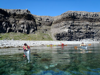
Once we were all on the water we paddled out through the pond and made for the exit into Conception Bay.
Thirty minutes later we were along the shore of Kellys Island and making our way in a southerly direction.
As we pulled into one of the few places to take out I noticed someone on the cliffs above with a metal detector. I don't think the person was going to find Peter Easton's pirate treasure rumoured to be burried on the island.
We got out for a stop and ...
Scaled the steep path to the top of the island where we had a spectacular view of Conception Bay and looked down upon our ...
... matchstick sized kayaks below.
We got under way to complete our circumnavigation of the island.
The rocks of Kellys Island are are fossiliferous shales and sandstones of the Ordovician period. Here we passed under sandstone beds topped by darker beds of shale. The change from sandstone to shale is evidence of a sudden change in depositional environment when the sea level rose preciptiously.
The beds strike northeasterly and dip to the northwest. They disappear under the bay and reappear on Bell Island where the rocks are younger. The estimated thickness for the sequence of rocks is some 8,000 feet.
The cliffs were just as imposing on the west side as we made our way around. Once around we sat in our boats for a few minutes before crossing back to ...
... Long Pond where it was red, right, return.
It was a fine day with a great bunch and the promise of warmer weather in the air.


No comments:
Post a Comment